Acatenango Volcano Guatemala
One of the most active volcanoes in the world is Fuego Volcano, just outside of Antigua, Guatemala. A popular way to experience the area is to climb and camp on the nearby Acatenango Volcano. Most people do the Acatenango Hike on one of the many an organised tours from Antigua. But there is another way. It is possible to Climb Acatenango Volcano Guatemala without a guide.
The Acatenango Volcano Trek is one of the best overnight hiking trips in Central America.
About Acatenango Volcano
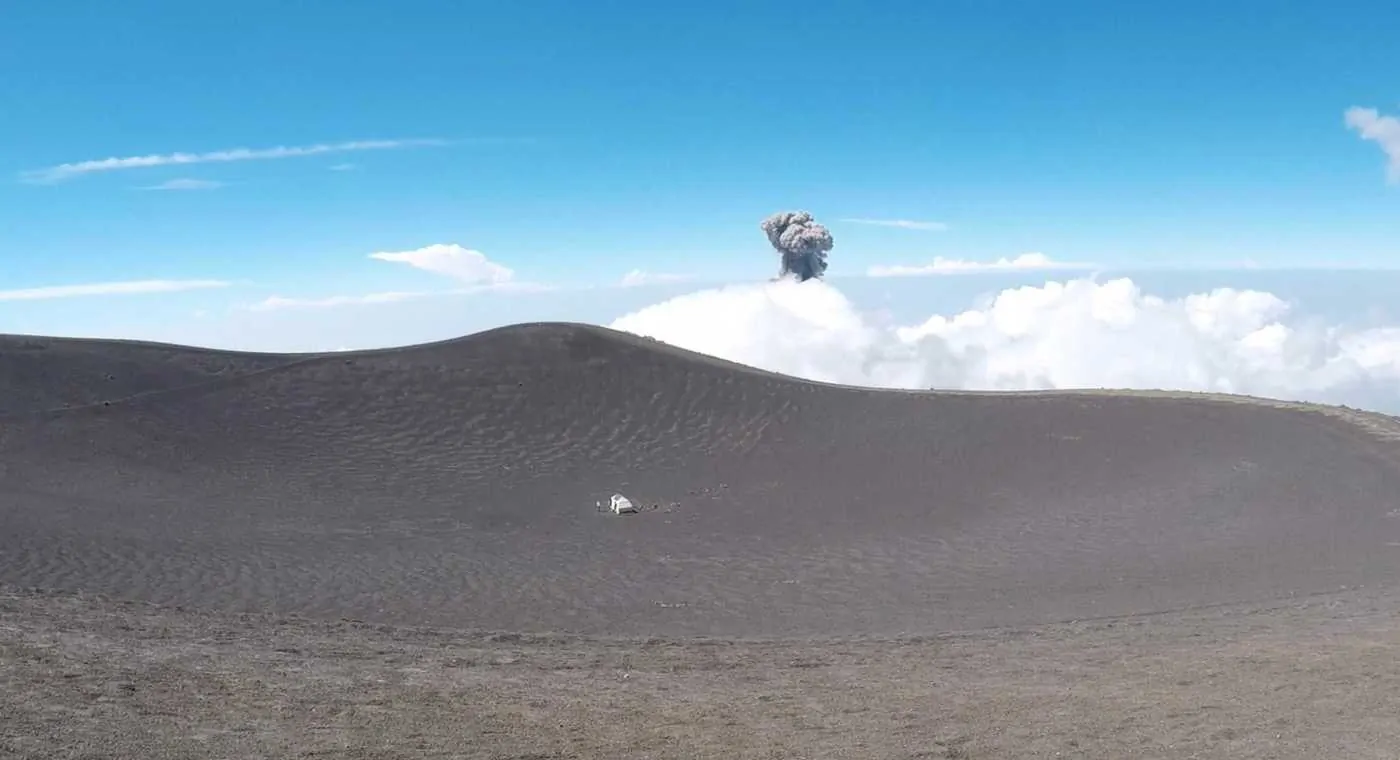
Acatenango Volcano in Guatemala was once very active, but not anymore. Despite a few steaming vents near the summit is currently not active. Only a couple of kilometers away is Fuego Volcano, one of the most active volcanoes in the world.
When I mention active, I mean, really active. This place erupts a couple of times per hours sending plumbs of volcanic ash and rock high up into the sky. When explodes, it sounds like a jet plane during take off.
Climbing Acatenango Volcano
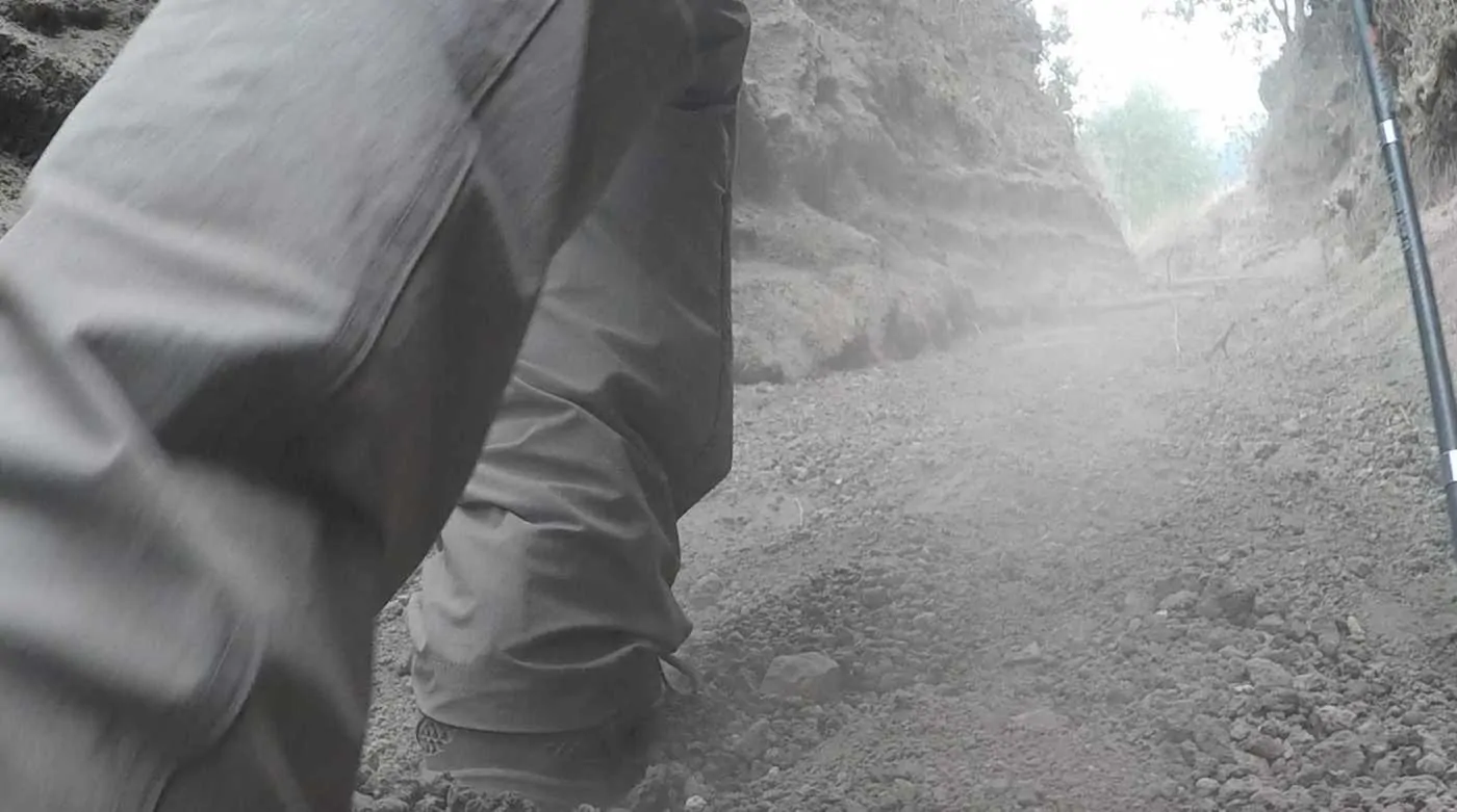
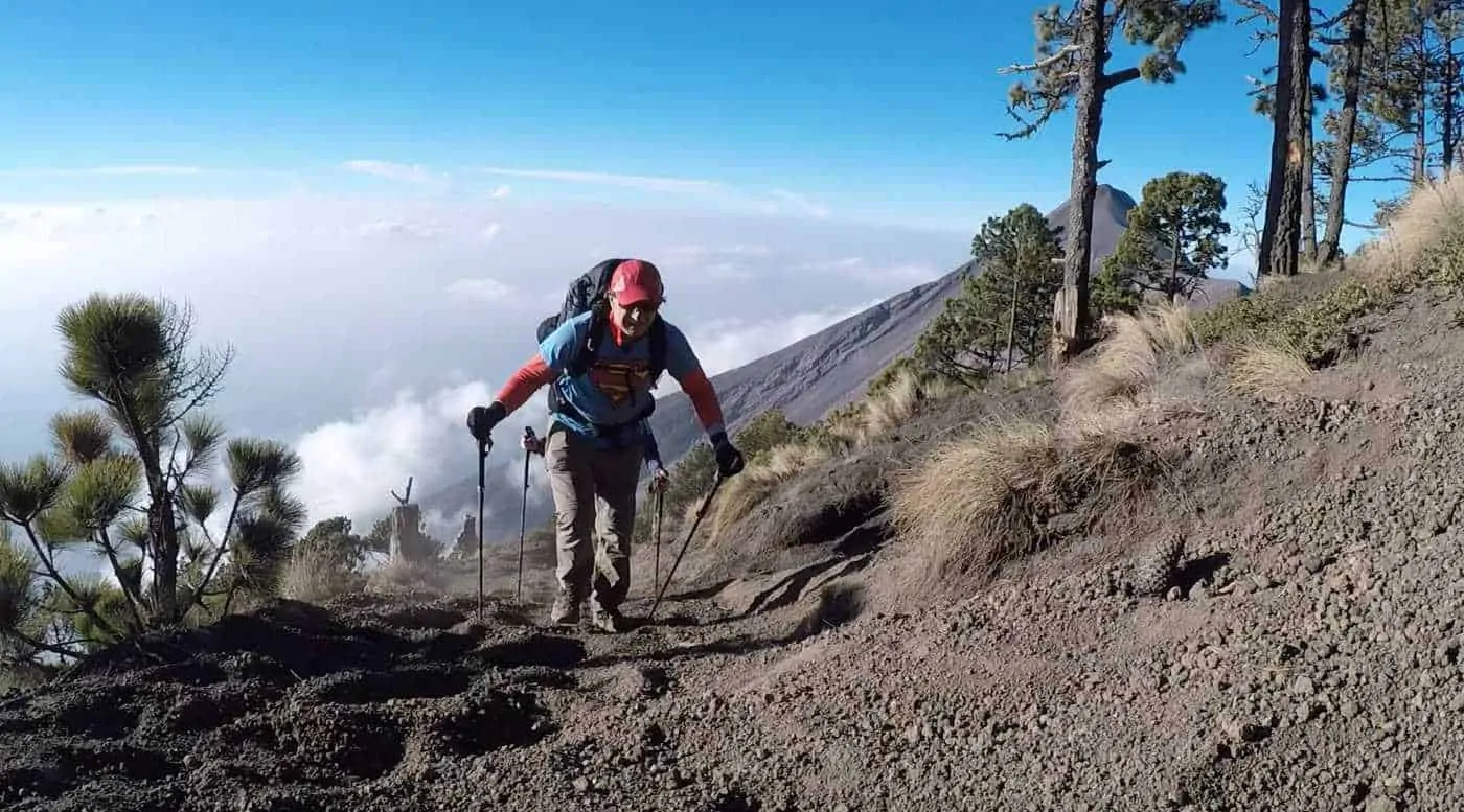
The trail started climbing right from the road on soft volcanic soil. Two steps forward, one step back. Although it was not to steep the lose volcanic soil made for slower than normal travel. Also, the start of the hiking trail was at 2450 meters so the air was already a little thinner.
After about an hour or so we reached a small family owned restaurant by the side of the trail, however, we overpacked with food so kept going. We would return to this place on our descent to enjoy their reasonably priced meals.
After maybe another hour we reached the park entrance and paid the $7 entry fee. There was also a dude selling snacks, fruit and drinks. Once agin we were tempted but as we were carrying so much of our own food it didn’t make sense to buy anything.
There is a large network of hiking trails in this area. Despite having a plan on where we wanted to camp we had no idea just how many trails were in the area. Luckily, we a met a guide from one of the highly recommended companies, GT Adventures. He filled me with lots of very useful information.
The Green and Red Trail
There are two main trails on Acatenango Volcano. The green trail and the red trail. The green trail is longer, less steep and goes to the best campground. The one that overlooks Fuego volcano. Any hiker going to this trail should take this trail for reasons I will reveal later.
The other trail, the red trail is steeper but more direct. All the campsites on this trail are very nice but have no views of Fuego Volcano. So, if you are planning on hiking Acatenango, be sure to take the Green trail.
In Fact, if you are not hiking independently, be sure that your tour company hikes and camps on the Green Trail. If they do not, then choose another company. The photos below will be enough to convince you.
Back to the hiking. We had a quick snack at the park entry station and we set off for our campsite following the green trail. It is marked with occasional splashes of green paint on the trees at trail intersections. Again, if you plan to hike this trail. Follow the Green Trail!!
The trail continued ever upwards. The soft volcanic soil of of the lower elevations gave way to a mostly hard packed trail. On the Green trail we made good time. It took around 5-6 hours of hiking from the start of the trail to make it to the campsite. Low cloud and cold weather greeted us as we set up our tent.
Camping on Acatenango Volcano
On the side of Acatenango there were a series of flat sections big enough to pitch a tent. These have been carved out of the side of the volcano and there is enough space for hundreds of tents. Our friendly guide said it was no problem to camp there. In fact, he offered us water, which we refused because we packed so much of it.
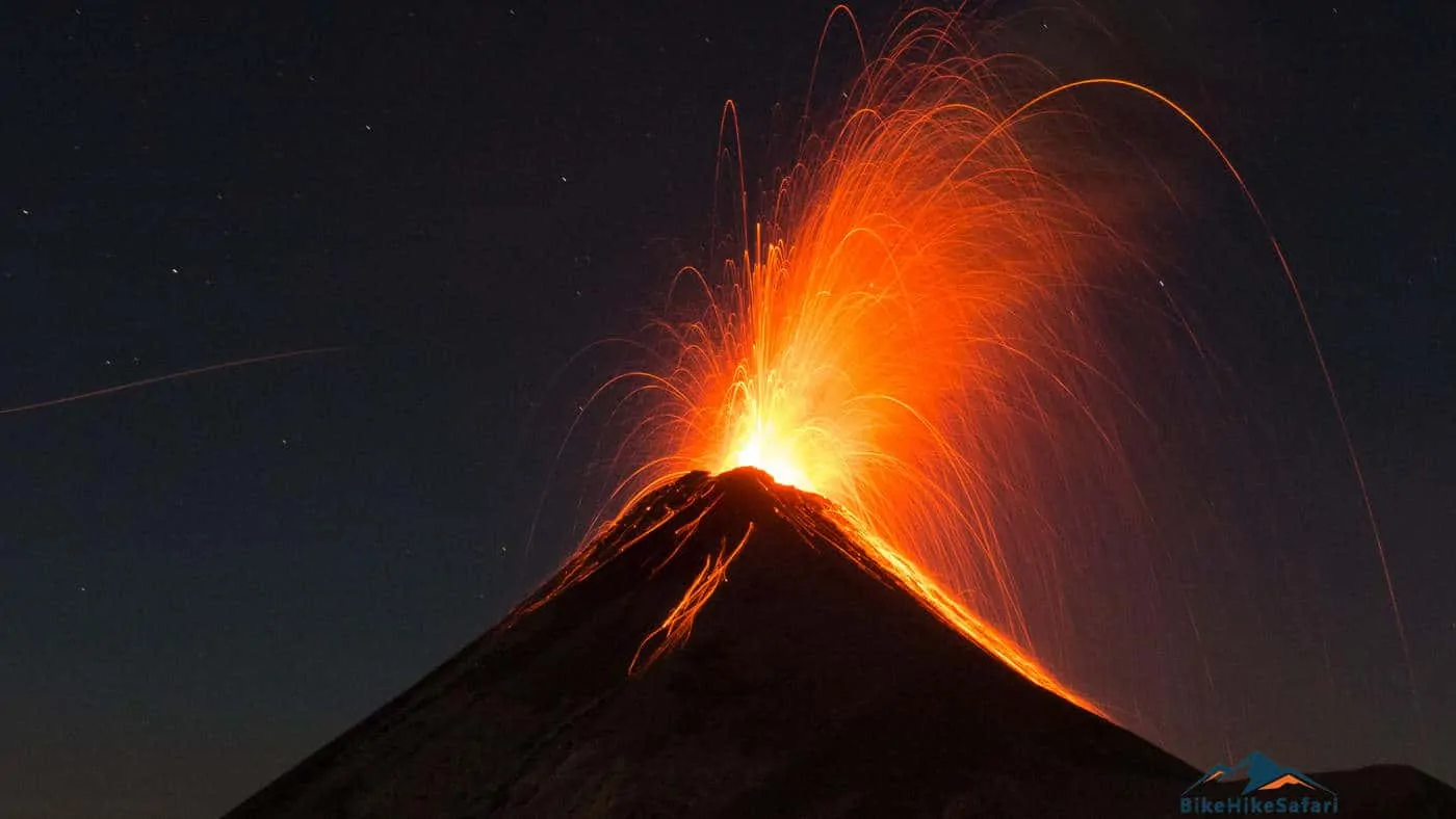
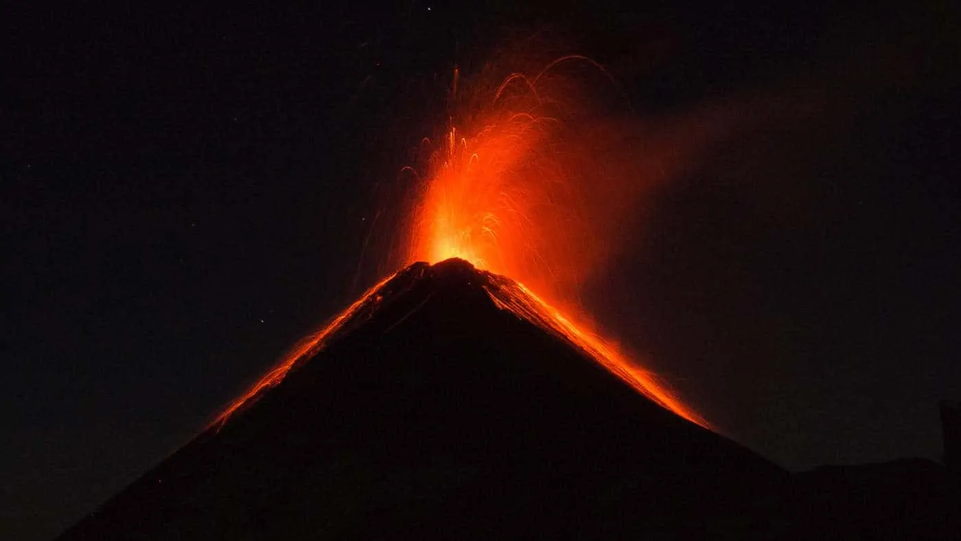
This flat campground was only a couple of kilometers from the explosive Fuego volcano. The view from the tent when the clouds cleared was nothing short of spectacular. I will let the photos a little further below do all the talking.
There are several places to camp on Acatenango Volcano Guatemala. But really, the only choice is on the south side of the volcano facing Fuego Volcano. The campsite is about 3 kilometers from Fuego which erupts a couple of times per hour why would you consider camping anywhere else. This campsite is at 3550m and is very cold.
There are other official campsite on the Red route but there are no views from these camps. Take my advice, camp on the sites on the south face. And if you choose to take a tour be very certain that they camp here. I’d be pissed off if they didn’t! Remember, take the green route!

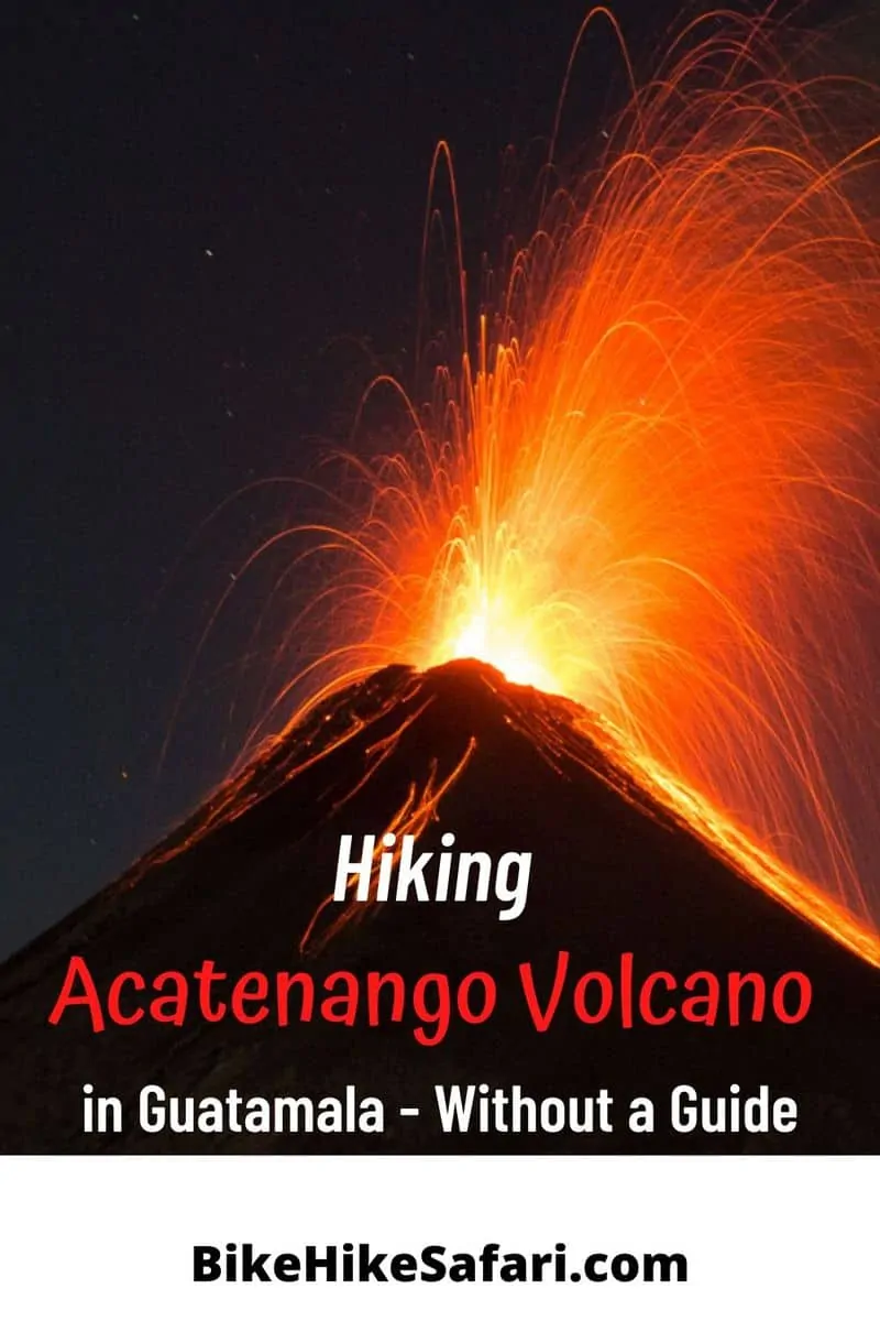
Fuego Volcano at night time
From the front door of our tent the weather cleared as the darkness approached. The temperature was now below freezing at 3550 meters. A couple of times per hour Fuego volcano exploded in a shower or red molten rocks. Natures version of a fireworks display. Seconds after the explosion came the sound. Kinda like a jet plane at take off.
For several hours we sat and watched nature display to us that we are not in complete control of the environment. It was not only an awesome display but something will not quickly forget. In all my life and in all my travels this is one of the most powerful displays of nature I have ever witnessed. I felt very small. Just a small dot on this world that could be wiped out if nature so chose.
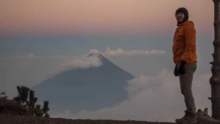
The climb to the summit of Acatenango Volcano Guatemala
All the guided tours wake up at silly o’clock to reach the summit of Acatenango Volcano for sunrise. The result is summit crowded with people trying to take selfies when Fuego erupts. We chose to enjoy sunrise from our campsite. We would head up to the summit later in the morning. At 3976m it was still a little bit of a climb.
This later start made for warmer weather. The pace was very slow. A combination of high altitude and very soft volcanic soil. Again, it was very much two steps forward and one step back.
The wind at the summit was relentless but manageable. It wasn’t long before the clouds started to roll in. Anyone heading up there after midday would be heading into the white soup of clouds. I pity their lack of views.
We took enough time at the summit to chill out and take in the views before slipping and sliding our way back down. The route we chose to take us back to the road was via the Red route. I can attest that it is steeper but shorter and a good alternative for the descent.
Information for independent hikers
Getting to the start of Acatenango Volcano
We set of from Antigua on a local bus to the town of Parramos. Any bus heading to the town of Chimaltenango will drop you off there. We walked across the plaza then take another bus to the start the trail near La Solidad. Any gringos in this part of the world are going to climb Acatenango volcano so the drivers will know exactly where to take you.
Camping and permits for Acantenango
There are a couple of campsite on Acantenango. Make sure you follow the green trail and camp with a view of Fuego. The campsites on the red trail do not have a view. This is really important. In fact, if you are taking a guided tour ask which trail they take and where they camp, only a couple of guided companies take the green trail. Companies like Ox and GT. I met and spoke with their guides so if you are not confident to go alone use one of these tour companies. They seemed very professional.
Permit cost are 50Q (around $7) and can be purchased at the entry booth about 1 hour walk from the road on the hike.
Food and water
There is a restaurant about an hour from the road with reasonably prices meals. We stopped there for lunch on the descent. We carried all our water for the 2 days, however, we could have bought water at the restaurant and we could have got some water at the campsite from the guided companies. But best not rely on this and be self sufficient. There are no water natural sources on the hike.
Maps
We used an offline maps from Pocket earth Pro App, my go to hiking, bicycle touring and travel map. It showed the campsites and most but not all of the trails. Maps.me or Gaia would also work well offline.
Altitude Sickness
The campsite is at 3550m and the summit of Acatenango is at 3976m. I suffered from minor altitude sickness at camp. Just enough to feel minor tingling in my fingers and lethargy. Luckily it did not stop me from enjoying and climbing the volcano.
Camping gear and clothing
It is damn cold. The campsite was at 3550 m and the temps were around freezing overnight. After an extended period in the tropics this cold weather was quite the shock. So make sure you take enough clothing to stay warm and make sure you have gear to protect from rain and strong wind.
Check out my Lightweight hiking gear list here
In 2017 cold weather gripped the volcano and several people died. This is not a place to be taken lightly.
Subscribe to my YouTube Channel
Would you like to climb Acatenango Volcano Guatemala? Need me to answer a question? Let me know in the comments below.
Next : Bicycle Touring El Salvador
Or maybe you might like to read:
Climbing La Malinche Volcano in Mexico
Bicycle Touring and Bikepacking Pages might like:
Bicycle Touring Gear List
Bicycle Touring Spares and Tool Kit
Cycling from Alaska to Argentina
Hi, great post. Climbed Acatenango last week and wanted to add. You absolutely do not need a guide, you can climb it solo the route is easy. I had several people try to coerce me into booking with a tour company. It’s starting to seem like indonesia, where tour companies eventually started acting like the volcanoes are theirs. Entry to the park is 50Q which includes camping. Watch out for anyone trying to make you pay more. Enough tourists willing to pay whatever they’re told without second thought have now passed through the area that even the “park rangers” have gotten greedy. They will try to tell you 400Q is the price to camp on the volcano. It’s not, it’s 50Q. I’m now unsure if these men have any relation with the government because one mentioned he was the one who built the hut where people pay and therefore have right over it. I refused to pay 400Q. And after some back and forth they agreed to 50Q but said I would have to camp on a campground that had no views of fuego. I accepted knowing well I was going to camp wherever I wanted. I found a flat area looking at fuego to camp and also had the tour companies hackle me. Saying only tour company clients could camp on that side of the mountain if I wanted to camp I would have to pay them. I laughed and refused, nature is everybody’s and the park entry fee is clearly marked at the beginning of the trial (50Q). I was very clear I wasn’t going to pay and after a while they gave up. Just keep in mind if you’re going to go solo expect some resistance from greedy conmen that will scam you into believing the mountain is theirs.
Seems like things are changing rapidly. Most people will be more comfortable using a guide so the info is relevant for those choosing to go without a guide. Thanks for the update.
Hi, thank you for a super good guide!
My girlfriend and I are planning to hike it next week, without a guide.. In our search for a tent to rent, we are talking to a lot of people, saying it is not possible/illegally to hike it without a guide. Our instinct tells us, that this is just because “everyone” wants to sell us guided tours, but we would like to hear if you might know if it’s legal to hike without a guide (and still pay entrance fee of course) :)
Sincerely, Jeppe and Astrid
There might be some truth in the fact that you need a guide. A couple of years ago things changed when there was a major eruption. Please contact me and let me know how you go so I can update the info for people going there in the future.
We have now hiked Acatenango and become a bit wiser:)
It is true things changed a few years ago, as Fuego had a major eruption, which changed the lookout place on Fuego a bit (we were told) – because of this it is not recommended to hike Fuego with no guide!
However, climbing Acatenango solo was no problem. From La Soledad to basecamp it is an “easy” hike as the path is a single track and easy to navigate (we used maps.me which was very precise). Getting through all the different basecamp was a bit tricky because of so many different paths (we hiked doing the night and it had become very fuggy, which did not help). From the basecamp to the summit it is pretty hard, because of the loose volcanic ground.
All in all it took us 4 hours from La Soledad to basecamp and 2 hours from basecamp to summit. We started at 11pm from Solodad and was back down around 10 am, as we enjoyed a long breakfast with a view on top:)
What time of year did you do this hike? I’m thinking about doing this hike next month in June, but have read Nov-Jan is best time. Do you have any insight about doing this hike in June, and why Nov-Jan is best?
I was there in February. I believe you can hike at anytime of the year, it just might be a bit rainy when you are there. November till March is the dry season and not much rain for the climb of Acatenango.
I think you’ve reiterated the use of the green trail 1000x. I won’t forget that. haha. Thanks for the trip report.
I’m planning on doing this whole hike in one day (day hike). Start at 5am, arrive at the peak by noon-ish, rest a couple of hours and descend. Descending via the red trail, as you advised.
Do you think I’ll have a view of Fuego around noon?
How bad would it be ascending and descending the same day? I know pretty fit.
Yes take the green trail. You might be ok with the weather, it often clouds over around the middle of the day, but that often depends on the time of the year. Almost certainly during the wet season. Good luck, let me know how it goes.
Hello!
We are currently in Guatemala after a year of travelling! We have never been on a tour as we like to do things our own pace! So would it be possible for us to get the local bus there and then hike to the campsites without booking? Can you just turn up? Do they have sleeping bags/sleeping mats etc? would there be places for us to have some food (we can buy food to bring with us also). Many thanks for any information! love your blogs, Emily
Just turn up and hike, but only if you have hiking and navigation experience. You will need to be self sufficient and take all your camping gear. You will need your own food as there is none at the designated camping sites. I mention the buses to take and other info in the blog which might help you out.
“Silly o’clock”! HAH! Yeah, I took a guided tour on this hike while I was in Guatemala – and that’s what it felt like. I actually did this hike twice. The second time I just asked myself why, why, why I did it again. Rough on the legs.
A lot of information here. One question though, how did get such a good picture of the eruption? My pictures all came out too dark to see what was going on. Thanks for the read, Brad! Brings back good memories.
Thanks for the kind words.
I pre set my camera to take 30 second exposures. As soon as it started I clicked the shutter, it was on a small gorilla pod tripod. I just sat next to the camera from my tent site ready to click. As you know it explodes so often I got loads of photos and video.