
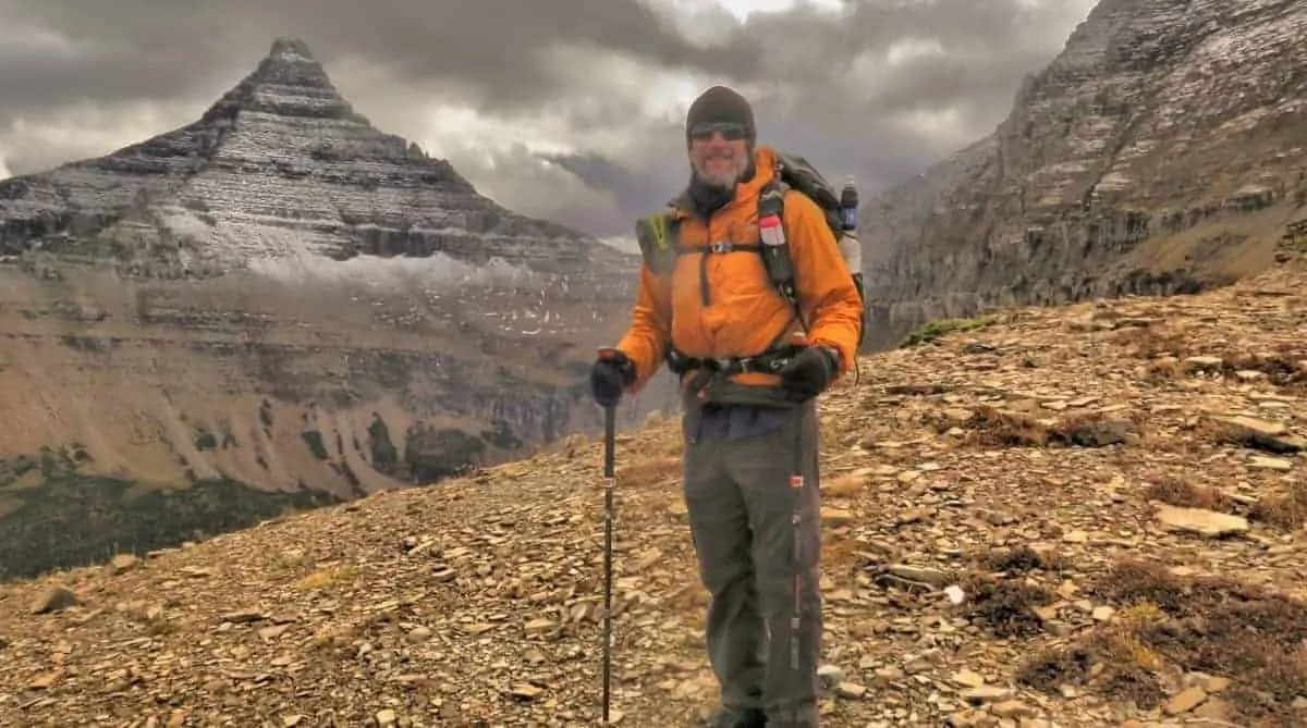
The Continental Divide Trail is one of the more difficult thru-hikes. I thru-hiked the CDT and understand not only how difficult it is but what information you need to know when planning your CDT thru-hike.
If you are Thru-Hiking the Continental Divide Trail in 2026 this comprehensive guide should answer most of your questions, inspire you to get out there and scare the crap out of you.
It includes a daily CDT Blog complete with cool photos, information on how to get to the trailheads at the northern and southern terminus, plus info on maps, apps, resupply, gear guides, permits, and guidebooks. If I missed anything, let me know.
Hiking the CDT Trail
Thru-Hiking the CDT was one of the toughest things I have ever done in my life. I documented my hike as a daily journal but over time it grew into a resource for anyone else wanting to hike the trail. I recorded my CDT Thru Hike in my daily journal which included what I was seeing and experiencing on the thru hiking the Continental Divide Trail. Often I was too exhausted to write about the day but I persevered. This is the result.
Anyone contemplating the CDT Thru Hike might find it useful to read all the blog posts listed below. If after reading the blog posts you still have questions then let me know. I would be happy to help any future hiker in any way possible. Just let me know.

Continental Divide Trail Gear
I was certainly not ultralight during my thru-hike. My Continental Divide Trail Gear List will give you an idea of the best ultralight gear for the CDT.
My gear is constantly being replaced as it wears out or I look to upgrade.
Below are reviews of all the best gear thru-hiking gear available at the moment.
Read More:
- Best Tents
- Best Sleeping Bags
- Best Backpacking Quilts
- Best Sleeping Mats
- Best Backpacks
- Best Down Jackets
- Best Rain Jackets
- Best Stoves
- Best Water Filters
- Best Filtered Water Bottles
- Best Headlamps
- Best Trekking Poles
- Best Backpacking Pillow
- Best Backpacking Cookware
- Best PLBs and Satellite Messengers

Continental Divide Trail Documentary
Subscribe to my YouTube channel
Continental Divide Trail Tips
NOBO vs SOBO vs Flip
NOBO is hiking Northbound, SOBOB is hiking Southbound and Flip means hiking sections of the trail that are best suited to the weather for that area. I’ll describe things a bit better below.
After deciding to backpack the CDT it is time to consider which direction to hike. There are advantages and disadvantages of Thru-Hiking the CDT northbound, southbound, or completing a flip-style hike. There is no perfect direction for the CDT Thru Hike. Southbound is the best option even though I hiked Northbound. Make up your mind.
Hiking the CDT NOBO
A CDT northbound hiker is plagued by the possibility of late-season snows in the San Juan Mountains of southern Colorado. Then there are the many thunderstorms in northern New Mexico and Colorado.
Hiking in the snow of the San Juan mountains is no joke. It honestly scared the crap out of me. I am not a mountaineer. It felt more like Thru Mountaineering the CDT than Thru-Hiking the CDT. I nearly set off 4 wet snow avalanches in one day it was time to bail from the mountains and take the lower Creede cutoff route.
Check out the San Juan Mountains in June – More like Mountaineering!

The trail both humbled and disappointed me when I had to bail off the trail. My safety was more important to me. It is only a matter of time before a Thru-Hiker dies while hiking early season in the San Juan mountains. Don’t plan on starting in Colorado before 7th June at the earliest. Be warned.
Thru Hiking the CDT northbound has several advantages that the southbound hiker does not have. It allows the hiker to start hiking slowly. Plenty of low miles at the start to allow their body to adapt to big miles. New Mexico is also very cheap in comparison to the other states, so spending an extra night or two in a hotel to rest early on in the hike is cheaper than the other states.
CDT Northbound Start Date
Most thru-hikers start the Continental Divide Trail in late April or early May. The ideal start date for thru-hiking the CDT Northbound would be 15th April. This would allow someone hiking the Continental Divide Trail northbound to not rush the trail and risk injury.
New Mexico is the cheapest state for the whole trail. Enjoy some rest days. Starting slowly it allows the snow to melt in Colorado.
Flip Flop Thru Hike of the CDT
The flip-flop method is not the best method for thru-hiking the CDT. The issue is the amount of early-season snow that can accumulate in Colorado and Montana makes both options bad. Also, many areas in Idaho and Wyoming are covered in snow in June too.
The San Juan mountains of Colorado are no place to learn about hiking in the snow. Hikers could start the hike a bit slower than they normally would or take some time off in northern New Mexico to allow the snow to melt.
Flipping north has the disadvantages. It will cost money to travel to Montana. Maybe your hiking buddies that you have met on the trail do not want to go with you. Worst of all the trail will finish at some road junction somewhere rather than at a monument at the border.

Hiking the CDT Southbound
CDT Southbound hikers are plagued with the possibility of late-season snows on the passes in Glacier National Park. The hiker must start at a time when it is safe to travel but early enough to give the hiker enough time to get through Colorado before winter sets in.
The worst thing about thru-hiking southbound on the CDT is the Bob Marshall Wilderness. It is a hard section of trail with difficult resupply options. Made worse by not being trail-fit and all the winter storms that have blown down trees. These will not have been cleared from the trail in June or even July. Making the hike slower than at other times of the year.
CDT Southbound makes for very cold weather in Colorado. Early-season winter storms in Colorado can force the hiker off the trail. Some thru-hikers have died in early winter storms on the CDT. Imagine having to road walk around all the most amazing mountains of Colorado and Northern New Mexico because of early-season snow. It is a possibility and might be a safer option than risking a hike in deep snow.
If I was Thru Hiking the CDT Trail again I would go southbound. Why? I think the chances of a successful hike are increased. Colorado will be brutally cold which I dislike. I would gear up for the cold in Colorado. Hiking southbound means being a little more trail-fit at the start of the hike in Montana. Long daylight hours should equal reasonably big miles.
CDT Southbound Start Date
Most hikers start their southbound hike from mid-June to the end of June. 15th June would be the ideal start date. The high passes in Glacier National Park will be snow-covered for most people starting on this date and the trails through the Bob Marshall Wilderness will be slower going due to all the winter tree blowdowns that have not been cleared. Keep that in mind when you determine how many days of food you need. It might be slower going than you think.
How Long Does it Take to Hike the Continental Divide? Trail?
Most thru-hikers will take 5 months to hike the Continental Divide Trail. Faster hikers who have completed other thru-hikes are confident in their ability and use ultra-lightweight gear will complete the trail in 4 months. Early-season snow and the early onset of winter make it almost impossible to hike this trail in 6 months or longer.
What is the Highest Point on the CDT?
Grays Peak is the highest point on the CDT at 14278ft / 4352m. Grays Peak has an easy hiking trail to the summit. The biggest difficulties of the hike are the weather and altitude.

Getting to the Start of the Continental Divide Trail

Getting to the Southern Terminus of the CDT requires a choice of 3 places to start or finish the CDT in the south. Antelope Wells, Crazy Cook, and Columbus.
The most common option to get to or from the southern terminus is to take the Amtrak train to the town of Lordsburg, New Mexico. Then take the CDTC shuttle Lordsburg to Crazy Cook.
Antelope Wells is another option. It is on Hwy 81 right at the Mexico border. A hitch or private transport would be the only viable way to get there. It is also the end or start of the Great Divide Mountain Bike Route that parallels the CDT. Columbus is just north of the Mexico border with Greyhound buses servicing the area.
Getting to the Northern Terminus of the CDT
There are two places to start or finish in the north, Waterton Canada or Chief Mountain. The easiest way to get to or from the start of the trail would be to take Amtrak services to East Glacier, Montana. From there take the shuttle to Chief Mountain.
For those returning to the USA after the hike. I hitchhiked and was lucky. The Shuttle runs till mid-September when the border crossing to the USA is closed. Be sure to check when things close if hiking late or early in the season.
Trail Towns and Resupply Points

I faced a problem with the CDT. Small-town USA is rather crap for providing good nutritious food.
Many times a grocery store didn’t have anything remotely healthy. No fruit and no vegetables. Everything was packaged crap food.
My body suffered from poor nutrition after about 2000 miles. In a desperate moment, I ordered protein powder and a large box of Mountain House meals to add at least a little nutrition to my diet. It did work.
Amazing how nutritious food can make a difference with energy levels. For a complete guide to resupply on the CDT, including towns, mileage, mailing addresses, and phone numbers, click the link below.
CDT Guidebook
There are no good CDT Guidebooks. Yogis Guide used to be good but hasn’t been updated in many years.
Read my Resupply Guide for the Continental Divide Trail which I hope to update for the 2026 hiking season.
Download the FarOut Guides to your smartphone for the best info on the trail, including maps and trail town info.
CDT Permits for Glacier NP and Yellowstone NP
Glacier National Park has a reservation system for all the backcountry campsites. Southbound hikers have it easy. They can pre-plan their arrival dates and organize permits over the phone. Northbound hikers have two options. Call ahead and book their sites or turn up at the Back Country Ranger Station at Two Medicine and arrange for permits. Both systems are not ideal but it is the only way.
Click here for further info on Glacier National Park Permits.
Backcountry Permits for Yellowstone National Park are slightly frustrating for the CDT hiker. Mostly because it can be hard to call ahead and pre-plan what campsites they will be in.
The most common option is to camp just outside the park and hike to the nearest backcountry permit office to organize permits. Northbound hikers must hike 27 miles to Grants Village. Southbound hikers must hike 18 miles to Old Faithful Village.
Click here for further info on Yellowstone National Park Permits.
Continental Divide Trail Maps
Digital and paper maps of the CDT exist but are rarely used by anyone these days.
My iPhone was my only form of navigation aid when I hiked the CDT. I was in the majority. Few hikers carry paper maps, and even fewer have a compass.
The best choice of maps is the FarOut Guides which works with your smartphone. Download the maps for offline use.
As for the use of a dedicated GPS unit like a Garmin, I only spotted one person using one on the CDT but most use Smartphones nowadays.
Times are changing. Technology is changing. Using the built-in GPS on the phone is the future. I am one of the many who are embracing the future. But it has also created a false sense of security for many hikers. Technology can fail. Paper maps can blow away in the wind.
To protect my technology I used a phone battery bank to keep things charged. More importantly, I used a Case to protect the phone. A broken phone equaled a broken hiker.
Smartphone Apps for the Continental Divide Trail
Farout CDT Guide
Almost every CDT hiker uses the FarOut App. The FarOut Guide has improved a lot in recent years and I can’t think of any reason why you would not use it.
Avenza PDF Maps
This app is free, and so are the Ley Maps. Download the App and search for Ley Maps CDT. Turn on the location services for the App and you have a free mapping App for the CDT.
The advantage of the Ley maps is the alternate routes and mentions of water sources not listed on GutHook. The thing with the CDT is the alternates are oftentimes a more scenic option or a shortcut on the trail. The ‘Official CDT’ is not always that scenic.
Pocket Earth PRO Offline Maps
To navigate around towns and get me off trails in emergencies or to detour around fires I use an Offline Topo called Pocket Earth Pro. I download the whole state topo map to my phone.
If I need to bail off the trail, this is my go-to map. It also shows hotels and restaurants etc. There are a lot of handy Wiki Travel links on the offline maps with info such as historic sites.
Many people use the Gaia App and rate it highly.

CDT Water Report
The CDT water report used to be the best info for water on the trail. It seems now that the FarOut Guides are now the best source of information about water sources.
The CDT is quite a dry trail. Every state on the trail has long sections with little water. The deserts in New Mexico are dry in many places. Cattle ponds and electric windmills are the only water sources for many miles.
Many of the high ridges in the Rocky Mountains of Colorado also have sections of little or no water. The Great Basin in Wyoming is notorious for long sections of little water. The same is true for the ridge-top walking in Idaho and Montana.
Suffice it to say there are a lot of dry sections on the CDT. FarOut Guides have improved a lot and are now the best source of info.
Snow Conditions on the Continental Divide Trail

A late-season snow melt will mean many potentially dangerous situations. Many an experienced snow hiker has been humbled by a combination of dangerous snow, bad weather, and slow travel.
Northbound hikers should consider starting in Colorado after 7th June. Every year is different but it is almost guaranteed that there will be snow to deal with.
The southbound hiker has the advantage of only really getting a short section of snow in Glacier National Park. Mainly at the Passes. 15th June is generally accepted as the safest start date for SOBO.
Snow depth chart for the Continental Divide Trail
Wildlife on the CDT
Thru Hiking the CDT puts the hiker in a position to have wildlife encounters. In 2016 two Thru Hikers were mauled by Grizzly Bears on the CDT. Both lived to continue hiking. The attacks occurred in the same area between the Wind River Range and Yellowstone National Park in Wyoming. Possibly by the same bear.
The hikers, Zorro and Smiley were hiking solo and the Bears attacked with little warning. I met both of these hikers while on the trail. Smiley had particularly nasty puncture wounds on his butt.
I had a Grizzly Bear walk past my tent in the same area as I slept. The following morning I discovered the bear tracks only 20 feet from my tent. I had my food in my tent and was not carrying bear spray at the time. Luck was on my side, I had a close call. I learned my lesson and took precautions after those acts of stupidity.
Hang food and carry bear spray between The Great Basin of Wyoming and the Canadian border.
Rattlesnakes were common in New Mexico and in places in Wyoming. One attacked my GoPro while shooting some close-up video! There are also Moose, Bison, Wolves, Wolverines, Mountain Lions, and Lynx.

Know Why You Are Thru Hiking the CDT
During times of hardship, you will question why you are doing this to yourself. Maybe you haven’t seen another hiker for many days or survived a winter snowstorm and are running low on food with many days to hike to the nearest town.
Have a serious think about your reason for hiking the trail. For me, it was always about nature, the scenery, the wildlife, and the challenge of completing a hard thru-hike.

Top 5 Days on the Continental Divide Trail
- The Gila River – New Mexico
- San Juan Mts – Colorado
- Cirque of the Towers – Wyoming
- Yellowstone NP – Wyoming
- Glacier NP – Montana
If I hiked the CDT Again
If I were Thru Hiking the CDT again what would I do differently?
Firstly, I would prefer to be Thru-Hiking the CDT southbound. It offers a better chance of success for the hiker who has a bit of trail fitness.
Secondly, I would send more food boxes with nutritious meals to some of the small towns in Idaho and Montana.
Thirdly, I would spend less time in the trail towns of Colorado, they are expensive.
And finally, I would take more neros and less zeros. I had lots of zero days in the trail towns.
Travel Insurance for Overseas Thru-Hikers
CDT Hikers traveling from overseas will need some form of Travel Insurance. Read the fine print. Especially when it comes to traveling at altitude as many providers will not insure you when traveling above 3000 meters.

Continental Divide Trail Blog – Pre-Hike Information
- Hiking The CDT
- Resupply for the CDT
- Continental Divide Trail Hiking Gear List
- Preparing for the CDT
- CDT Trail Days

Continental Divide Trail New Mexico
Continental Divide Trail New Mexico is home to rugged desert mountains and some of the cheapest trail towns on the whole CDT. A great place for northbound hikers to take their time and get trail fit. Southbound thru hikers on the CDT can enjoy fast days with big miles if they so choose, or slow down and enjoy the last weeks on the trail. The many Nation Forests make for great hiking and camping.
- Day 1 The Beginning
- Day 2 Hard Work
- Day 3 Easy Miles but still hard
- Day 4 I love the heat
- Day 5 I survived an 80MPH Sandstorm
- Day 6 When Rattlesnakes attack
- Day 7 Into the Woodlands
- Day 8 Gorge Walking Road Walking
- Day 9 Silver City equals Pizza
- Day 10 A Day of Rest
- Day 11 Heavy Legs
- Day 12 The Gila River
- Day 13 Gila Cliff Dwellings
- Day 14 Narrow Gorges and Hot Springs
- Day 15 From the Gila River to the Grasslands
- Day 16 Roadwalking, from lost to found
- Day 17 Fatigue sets in
- Day 18 Disgusting Water
- Day 19 Pie Town
- Day 20 Pie Town to the Ranch
- Day 21 Roads Storms and Clouds
- Day 22 Looking Forward
- Day 23 Into the Town of Grants
- Day 24 Rest and Recovery
- Day 25 Don’t pick up hitchhikers
- Day 26 The Sport of Postholing
- Day 27 I love New Mexico
- Day 28 Storms and Snakes
- Day 29 Outrunning the Storms
- Day 30 Rest Day in Cuba
- Day 31 Into the Cold Mountains
- Day 32 Snowy Mountains to Red Rock Canyons
- Day 33 Ghost Ranch
- Day 34 Onto the Colorado Plateau
- Day 35 Lost in the Snow
- Day 36 Is that a Wolf
- Day 37 I Just Walked Across New Mexico
- Day 38-40 Rest Days in Chama
Continental Divide Trail Colorado
The Continental Divide Trail Colorado is the coldest section of the whole trail, both for the northbound and southbound thru-hiker. Late-season snow and thunderstorms for the northbound thru-hiker and cold frost and early-season snow for the southbound hikers. Arguably, Colorado is the most visually stunning section of the trail.
- Day 41 Well Hello Colorado
- Day 42 I’ve Never seen so much snow
- Day 43 Thru Mountaineering a Day to Remember
- Day 44 Fear Gets the better of me
- Day 45 Escape from the mountains
- Day 46-47 Pagosa Springs
- Day 48 And the thunder rolls
- Day 49 Altitude Sickness
- Day 50 15 hours of hiking
- Day 51 The retreat from the snow
- Day 52 Getting to town is not easy
- Day 53 Creede
- Day 54 Back on the trail alone
- Day 55 Finally I’m doing easier miles
- Day 56 Following the Colorado Trail
- Day 57 A night in a log cabin
- Day 58 Monarch Pass
- Day 59-61 Salida
- Day 62 Sad to leave Salida
- Day 63 Emotional Rollercoaster
- Day 64 More Passes and No Water
- Day 65 Hike Naked day
- Day 66 Into Twin Lakes for a rest
- Day 67 Too Tired to continue
- Day 68 I just hiked 1000 miles but I’m still in pain
- Day 69 From great to average
- Day 70 It’s time for a rest
- Day 71-76 Back on Trail
- Day 77 My favourite section of the trail so far
- Day 78 Climbing to the highest point of the CDT
- Day 79 This trail is brutal
- Day 80 Down and Up of Trail Life
- Day 81 Three beers on a hot day
- Day 82-83 Back to the Mountains
- Day 84 The Last of the Tall Peaks
- Day 85 From the mountains to the plains
- Day 86 The kindness of strangers
- Day 87 Last Day in Colorado
Continental Divide Trail Wyoming
The Continental Divide Trail Wyoming is a place for hiking big miles. From the flat and easy sections of the Wyoming Basin to the most visually stunning section of the whole CDT in the Wind River Range. And let us not forget Yellowstone National Park. South of Yellowstone National Park is an area with many Grizzly Bears where several incidents have happened. Carry Bear Spray and hang food.
- Day 88 Hello Wyoming
- Day 89 Back on Track
- Day 90 Into the Wyoming Basin
- Day 91-92 Rawlins town day
- Day 93 Sunsets and Moonrises
- Day 94 Mustangs and Pronghorns
- Day 95 1500 miles
- Day 96 Grand Sunsets
- Day 97 Atlantic City
- Day 98 Heading into the Winds
- Day 99 Hiking the Cirque of the Towers
- Day 100 I’m exhausted or sick or both
- Day 101 Sick on Trail
- Day 102 Cryptosporidium and Wildfires
- Day 103 Rest Day in Pinedale
- Day 104 Feeling better back on the trail
- Day 105 High Glacial Mountains to Green river valleys
- Day 106 Fires and flowers
- Day 107 I’m hungry
- Day 108 Togwotee Lodge food break
- Day 109 There’s a bear in my campsite
- Day 110 Hiking Yellowstone National Park
- Day 111 When Grizzlies attack
- Day 112 Trail Reunion
- Day 113 Valley of the Geysers

Continental Divide Trail Idaho
The Continental Divide Trail Idaho brings sections of trails with a seemingly endless rollercoaster of hills. Constant up and down hiking in the hills. Some of the resupply towns are difficult to reach. It is the time when both northbound and southbound thru-hikers will need to make big miles to avoid the snow which will be arriving soon.
- Day 114 Hello Idaho
- Day 115 Hiking the headwaters of the Missouri River
- Day 116 Eating Berries
- Day 117 Hiking the Montana-Idaho border
- Day 118 Lima town break
- Day 119 No energy today
- Day 120 The Montana and Idaho Rollercoaster
- Day 121 Long days of rolling hills
- Day 122 2000 miles plus
- Day 123 Leadore Idaho
- Day 124 Tired again
- Day 125 Following in Lewis and Clark footsteps
- Day 126 Roadwalk Detour
- Day 127 Last full day in Idaho
Continental Divide Trail Montana
The Continental Divide Trail Montana has some of the most stunning and difficult terrain. The rugged sections of trail Glacier National Park and the long resupply sections of the Bob Marshall Wilderness are the highlights. It is also a place to beware of Grizzly Bears. hanging food at night is a must.
- Day 128 Goodbye Idaho
- Day 129 Solo and struggling
- Day 130 Wildlife
- Day 131 Running Out of Food
- Day 132-133 Anaconda Ghost Town
- Day 134 Still moving north
- Day 135 Slow and Steady
- Day 136 Change of Plans
- Day 137 Trail Magic to Helena
- Day 138-139 Leaving the capital of Montana
- Day 140 Meeting with Friends
- Day 141 Snowing
- Day 142 To Lincoln
- Day 143 Into the Wilderness
- Day 144 A bit windy
- Day 145 I bear sprayed myself
- Day 146 Walking the Chinese Wall
- Day 147 Hiking through a Winter Blizzard
- Day 148 A cold day hiking in the snow and mud
- Day 149 Brutally cold
- Day 150 To East Glacier
- Day 151-153 Retreat from the Mountains
- Day 154 Still the wind is too strong
- Day 155-158 Waiting out the bad weather
- Day 159 Dangerous Snow covered Trail
- Day 160 Triple Divide Pass
- Day 161 Surprising a Grizzly Bear while hiking
- Day 162 A Perfect Day
- Day 163 Almost in Canada
- Day 164 I just hiked from Mexico to Canada on the CDT


Got any questions? Leave me a message below and consider sharing this post or signing up to may email list.
Enjoy the trail.
Cheers Shepherd – PCT15, CDT16, AT17, TA18-19 and still hiking.
Follow along on Social Media
BikeHikeSafari Gear Review Process
The author, Brad McCartney from BikeHikeSafari is a small independent adventurer and outdoor gear tester who owns and runs BikeHikeSafari.com.
BikeHikeSafari is not part of a large blog network and is proudly independent. All reviews on this site are independent and honest gear reviews of outdoor products by the author.
The author, Brad McCartney is a very experienced triple crown thru-hiker, adventurer, and bike tourer having spent 1000s of nights sleeping in a tent and sleeping bag (Read more). He was a manager of an outdoor retail store and is very experienced in what is important when using and testing gear for reviews like this.
BikeHikeSafari will never receive any money for reviews and they do not accept sponsored reviews on this website. All the comments about the gear reviews are from the author based on his years of experience. Hope this independent review was helpful for you.
thanks for the info and your willingness to share info. I have some questions. I am 64. In my 20’s I twice did the AT and once the PCT. Last year i solo hiked the lower 1550 miles of the CDT and I want to finally finish my triple crown this year. Given that I am hiking alone in my 60’s I need to be more cautious and I hike slower (13-15 miles per day is plenty for me.) I want to hike the basin starting may 20 or so. Need to get to encampment which I fear will still have snow. Do you know what the trail is like around the pass at encampment? What rivers might I have trouble fording? (I am a short woman). Is hoping to end up north by Sept 7th too late? Where does the snow linger into late june? Will I need an ice axe? I may hike from atlantic city south then flip north of yellowstone to ledore go south to atlantic city. then flip back to leadore and go north. I dont love flipping but like scary snow slopes even more. Any info would be so appreciated.
Hi Mary, I suspect Late May in the Basin may be a little too early, specially around Encampment. As you may know, when the snows are heavy at the start of Colorado for all the northbound hikers, many flip up north. Many find out that the snow is still very deep in many places. Maybe starting a couple of weeks later might be a better idea. But every year is different. As for finishing in September, you may get some snow and cold days. Snow will will linger in most / many places into late june but should not be anything much to worry about unless you are starting in Montana and hiking south. Overall the plan on flipping about so many sections could be reduced by just starting a little later in the season around late june.
Your links are not working on your CDT page
Should be working now, thanks
Greetings from Norway!
Me and a friend are planning to do the CDT next summer, but we have already started to look into things. We are wondering what you did regarding maps? Are they easy to buy as you get into towns, or did you order them in advance? We have found some useful stuff online, but those are hardly what we will bring with us on the hike. Also, what was aproximately the longest stretch withouth resupplying?
Thanks!
Ole
If you look at the blog post tips on the CDT which is linked on this page, you will see info on maps. I used smartphone maps only, no paper maps. Not too many people carry printed paper maps on the CDT but that us your choice of you do or not. My longest food carry between resupply was 200 miles, 320km. I hiked that distance in 7 days.
entries are showing up as not found! i hadn’t finished reading them all yet. i think the links were still working two weeks ago.
I will check when I get good wifi in about 4-5 days. Normally if you scroll to the bottom of the post there should be an arrow left or right indicating the next post or previous post. Sorry for the inconvenience, thanks for pointing it out.
Hi Paula, I think I fixed the problem, let me know if it is still not working. Thanks
*thumbs up* thank you!
Hey Brad – love the redesign, just as others have said.
Got my latest Backpacker Magazine the other day – you’re picture is in it! Your celebration at the northern terminus is on the back page of the mag. Very cool!
God speed, mate. Hope you’re enjoying your time off.
Mike M, Riverside, CA
Thank Mike, the new design is a work in progress. I’m enjoying learning new things about the cyber world. It was very cool to be in such a prestigious hiking magazine. Maybe another photo in there this time next year after hiking the AT. Take care and have a nice festive season. I’m back in the bike now.
Your dedication has not gone unnoticed. I appreciate the detail and will continue to refer interested hikers. Kudos! Looking forward to being a part of your continued journey.
Thank you for the kind words.
yes, it IS useful to read ! Thank you for spending time on this blog.
Thank you.
Seeing the hike all layer out like this really illustrates what a impressive accomplishment it is. Congratulations again!
-Pearl
Thanks Pearl. I’m very proud to have finished the hike.
New layout looks great! And thanks for organizing all your entries into one post.
Cheers
The new look is fantastic, Brad!
Thanks Peggy
Your trek was awesome. I had nothing but admiration for the strength and resilience you demonstrated. I waited expectantly for each post or series when they arrived together. And I enjoyed them enormously.
Good luck with whatever you do next – AT? I look forward to reading it and coming along for the adventure.
Thanks fir the kind words Phil. Yes I will be hiking the AT next year. First I’ll cycle through parts of Mexico.
I sooo enjoyed following you live your dream….many a day I thought: he’s gonna be too tired to blog the next day, and sure enough…..Old faithful, you are the inspiration for us deciding to pursue our dream to do the Ozzie Big Lap(in a vehicle haha) But we did a lot do cycling in Tasmania soon after your trip. We live in South Africa.
Thanks for the kind words. Yes many days I was too tired to write, sometimes the blog post reflects that. The big lap around Oz is a great dream, glad you have the chance to do it.
Just saw your completion pic of the CDT in the latest issue of Backpacker magazine. Congrats! Hope you are doing well. :)
Thanks, Alison. I’m fine. That was cool that they published the photo. Hope you are doing well.
Good to hear from you. What are you up to this holiday season?
Thanks Margaret. I’m in Mexico, I’ll be cycling around the countryside. Not sure where I’ll be for the festive season, I’ll let serendipity be my guide.
Hi Brad,
Looks like I would be part of ’23 class.
I am wondering about the alternates. Gila is the one for sure, and I incline to use Bonita-Zuni.
But what about Cebolla ?
It’s a shame to have to choose.
I wish you many new adventures.
Good to know you’ll be on the CDT. Gila is a must, most of the other options usually are decided by which one is shorter or easier cause the CDT will wear you out. Maybe see how you feel at the time and make the decision when
Can’t wait for you next adventure, have been following you since your first day on the PCT..
Thanks Roy. I’ll writing about my cycling in Mexico in the upcoming weeks. Stay tuned.
Love the re-design!
Thanks Ian.
I followed your CDT thru-hike daily and had read your PCT journal before you started the CDT. It has been great to follow along through all the tough times and the good and I look forward to following your hike on the AT next year. I will be starting the CT mid-July for 5 weeks and hope to keep up with journal posts on my blog daily too. Thanks for sharing the adventures with us
Thanks for the kind words. You will love the CT. I’m looking at doing more hiking after the AT next year. I’m torn between the the CT, Wonderland Trail or GDT in Canada. I’m leaning towards the CT, even though I’ve hiked a lot of it when it joins with the CDT.